IALA Buoyage System A Complete Sailor’s Guide
Managing Maritime Traffic and guiding vessels to reach their destinations are the primary goals of maritime authorities all around the world. Safe Navigation in unpredictable waters needs a dependable and robust system of navigational aids that guide the vessel in waters, especially at night. The IALA Buoyage System was developed in 1957 to address this need. In pilotage waters, visual aids provide the best possible option to indicate a danger or a preferred channel to follow.
1:- What is the IALA Full Form?
The full form of IALA is the International Association of Marine Aids to Navigation and Lighthouse Authorities.
It is a non-profit international technical society established in 1957 to combine representatives from producers, consultants, research and training institutes, and authorities responsible for marine aids to navigation from all parts of the world. The organization aims to standardize marine navigation aids throughout the world for safe, efficient, and generally understood navigation for all people.
2:- What is IALA Buoyage System?
The IALA Buoyage System unifies the navigational aids to ensure safe and efficient marine navigation across the globe. This system is categorized into two regions, Region A and Region B; the system is divided to accommodate some historical aspects of differences in the buoyage practices that were adopted at different times.
This system conveys specific nautical information with varieties of buoys designed with different colors, shapes, and light patterns. Think of it as a system just like those roadside parking assistance lights and traffic symbols.
3:- What is Region A and Region B in the IALA Buoyage System?
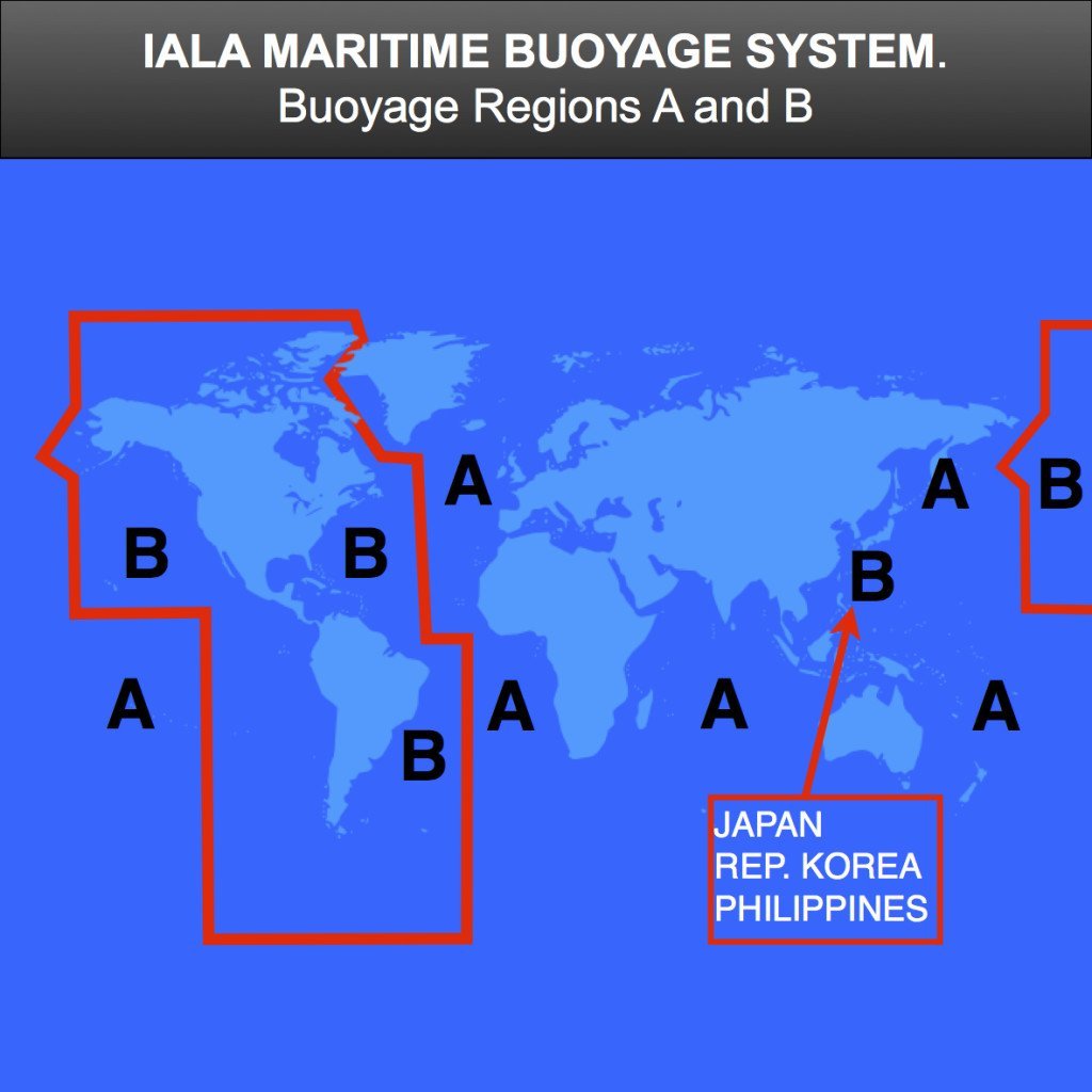
3.1:- Why are there 2 Regions in the IALA Buoyage System?
I have always wondered why there are 2 regions in the system. If you are standardizing something wouldn’t it be better if you do the same for all?
The IALA buoyage system is divided into two regions due to historical differences in maritime navigation practices. Region A (Europe, Africa, and most of Asia) uses red buoys for port and green for starboard when entering a harbor, while Region B (Americas, Japan, and others) reverses this, using green for port and red for starboard. This division allows countries to maintain their traditional buoyage systems while still ensuring global safety and consistency in navigation. Despite the color difference in lateral marks, other buoy types, such as cardinal and danger marks, are the same in both regions.
3.2:- What is the Difference between Region A and Region B in the IALA System?
The primary difference between the two regions is the color and characteristics of the lateral marks which will be discussed later. For basic understanding, Region A countries use red lateral marks to indicate the port side and Region B countries use green marks to indicate the port side.
4:- IALA Region A Countries
The following countries are considered as region A countries:
- All Countries in Europe
- All Countries in Africa
- Most Countries in Asia
- Australia and Oceania
- Countries in the Middle East- Qatar, Bahrain, Oman, etc
5:- IALA Region B Countries
The following countries are Region B Countries in the IALA Buoyage System:
- The Americas (North and South)
- Canada
- Japan
- South Korea
- Philippines
- Some Island in Australia and Oceania
6:- Types of Marks in the IALA Buoyage System
Each type of mark in the IALA Buoyage System has a specific purpose. As the entire system is standardized globally, the slightest details hold significant meaning. The following six types of marks are used in the IALA Buoyage System:
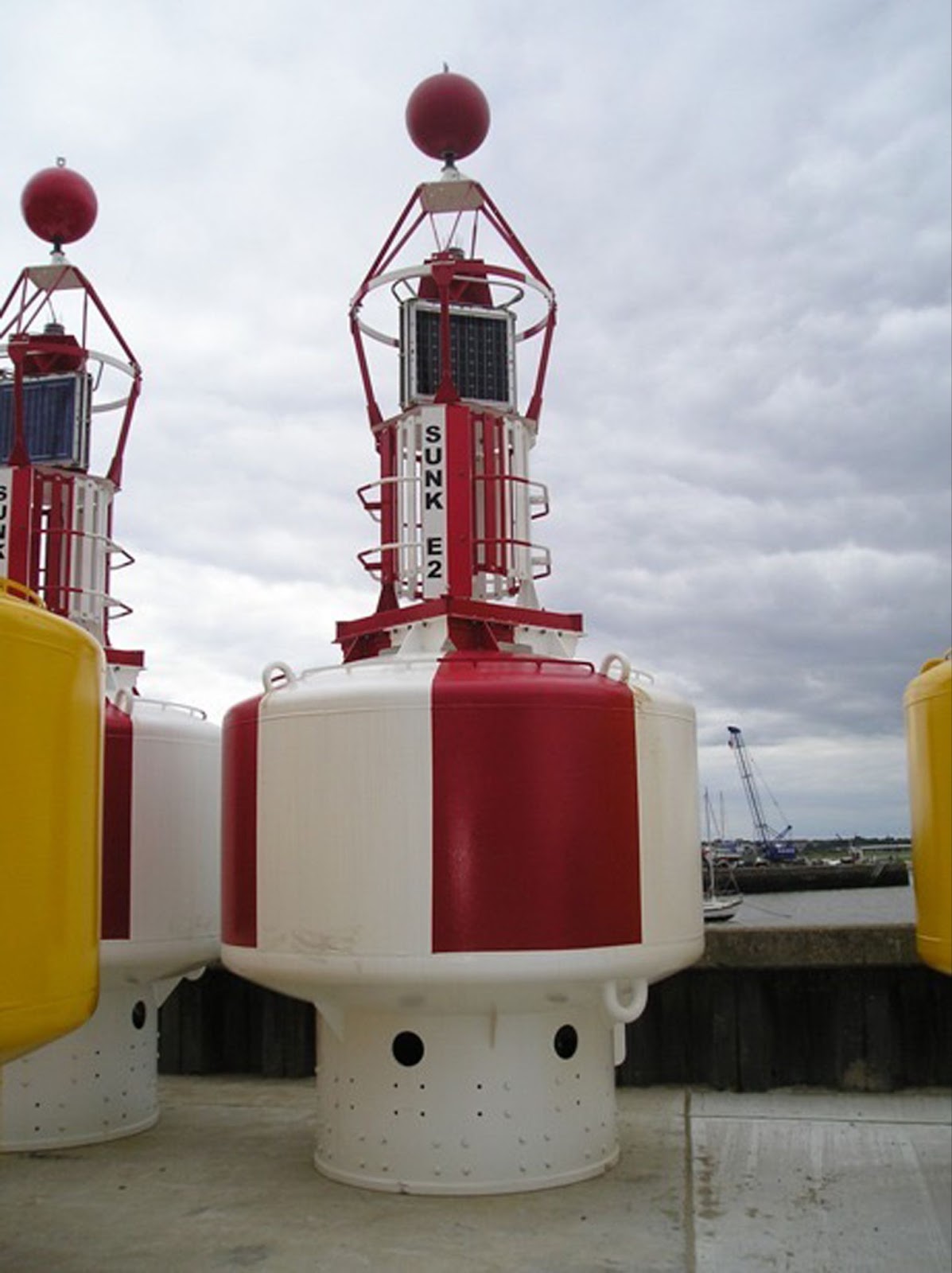
6.1:- Lateral Marks:
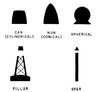
The term ‘Lateral’ means ‘side’. Lateral marks indicate the Starboard or Port Side of the channel or fairway. They indicate which side of the channel, the vessel should be going. The Port Lateral marks should be kept on the Port Side (Left) side of the vessel, while the Starboard Lateral Marks should be kept on the Starboard side of the vessel (right) when it is approaching the harbor. It is that simple! However, the direction of buoyage is particularly important when it comes to lateral marks.
They are generally of the shapes of a Spar, Pillar, or Buoy. To understand this, look at the image below:
As already mentioned, these marks are different for the regions A and B. The only difference between the two is the color of the buoy and the light.
Let’s find out the differences:
6.2:- Port Lateral Mark:
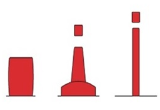
| Feature | Region A | Region B |
|---|---|---|
| Colour | Red | Green |
| Shape | Can Shaped(Buoy,Pillar or Spar) | Can Shaped (Buoy,Pillar or Spar) |
| Top Mark | Red Can | Green Can |
| Light | Red | Green |
| Rhythm of Light | Any( Except Group Flashing 2 + 1) | Any( Except Group Flashing 2 + 1) |
6.3:- Starboard Lateral Mark:
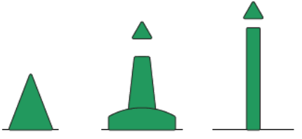
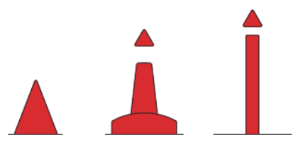
| Feature | Region A | Region B |
|---|---|---|
| Colour | Green | Red |
| Shape | Cone Shaped | Cone Shaped |
| Top Mark | Green Cone | Red Cone |
| Light | Green | Red |
| Rhythm of Light | Any( Except Group Flashing 2 + 1) | Any( Except Group Flashing 2 + 1) |
6.4:- Practical Actions on Sighting Lateral Marks:
The direction of the buoy is specified on the chart by a Purple Arrow. If you look at the above diagram, The Port Lateral marks in region A are red in colour and hence indicate the port side of the channel. When following the direction of Buoyage, Port Lateral Marks are to be left on the port side of the vessel. However, when running opposite to the direction of buoyage, they are to be left on the starboard side of the vessel.
Similar principles apply to the Starboard Lateral Marks as well.
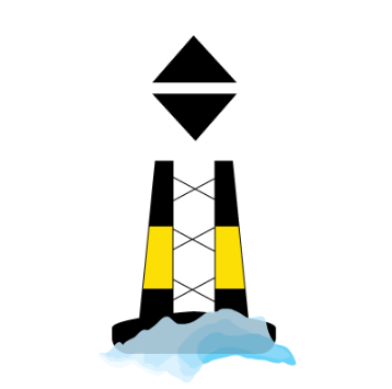
6.5:- Preferred Channel Marks in IALA Buoyage System:
These are a special type of lateral marks. They are present to indicate a preferable or recommended channel when the waterway splits into two. The primary purpose of a preferred channel mark is to guide mariners take the better and safer way to reach their destination and hence, increase overall safety. As in the case of other lateral marks, their color and the lights vary in Regions A and B. It has a primary color and a stripe. The primary color indicates the side of the main channel to be followed and the stripe indicates that there is an alternative channel to the other side, which is preferable:
6.6:- Preferred Channel to Starboard:
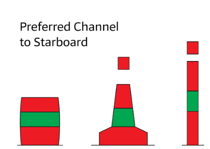
| Feature | Region A | Region B |
|---|---|---|
| Color | Red with green stripe | Green with red stripe |
| Shape | Buoy, Pillar or spar | Buoy, Pillar or spar |
| Top Mark | Red Can | Green Can |
| Light | Red | Green |
| Rhythm of Light | Group Flashing (2+1) | Group Flashing (2+1) |
6.7:- Preferred Channel to Port
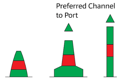
| Feature | Region A | Region B |
|---|---|---|
| Color | Green with red stripe | Red with Green stripe |
| Shape | Buoy, Pillar, or spar | Buoy, Pillar or spar |
| Top Mark | Green Cone | Red Cone |
| Light | Green | Red |
| Rhythm of Light | Group Flashing (2+1) | Group Flashing (2+1) |
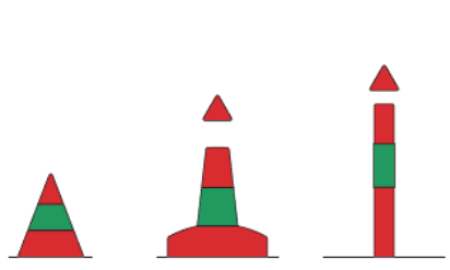
7:- Cardinal Marks in IALA Buoyage System
The word ‘Cardinal’ refers to the directions on a navigational compass. Cardinal Marks in the IALA Buoyage system indicate cardinal directions of underwater hazards and obstructions. They essentially mark the cardinal extent of safe water, that is which side is the safest side to pass an underwater hazard. As the name suggests, there are 4 types of Cardinal Marks:
7.1:- North Cardinal Mark
| Feature | Description |
| Colour | Black over Yellow |
| Shape | Buoy, Pillar,or Spar |
| Top-mark | Two Black Cones, Apex Upwards |
| Light | White |
| Rhythm | Very Quick or Quick Flashing( Q or VQ ) |
| Chart Symbol |  |
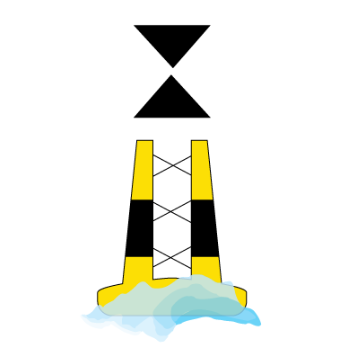
7.2:- East Cardinal Mark
| Feature | Description |
| Color | Black, Yellow, Black (From the top) |
| Shape | Buoy, Pillar, or Spar |
| Top-mark | Two Black Cones, apex apart |
| Light | White |
| Rhythm | 3 Very Quick Flashes in 5 seconds or 3 Quick Flashes in 15 seconds (Q(3) 15s or VQ(3) 5s) |
| Chart Symbol |  |
7.3:- South Cardinal Mark
| Feature | Description |
| Color | Yellow over Black |
| Shape | Buoy, Pillar, or Spar |
| Top-mark | Two Black Cones, apex downwards |
| Light | White |
| Rhythm | 6 Very Quick Flashes and a Long Flash of 10secs |
| Chart Symbol | 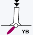 |
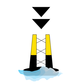
7.4:- West Cardinal Mark:
| Feature | Description |
| Color | Yellow over Black |
| Shape | Buoy, Pillar, or Spar. |
| Top-mark | Two Black Cones, apex downwards. |
| Light | White |
| Rhythm | 6 Very Quick Flashes and a Long Flash of 10secs |
| Chart Symbol | |
7.5:- Navigation when Cardinal Marks are Spotted
Say a North Cardinal Mark is Spotted. By meaning, the safest water should be on the northern side of the mark. As a result, a course will be steadied that takes the ship north of the cardinal mark
8:- Isolated Danger Mark
An isolated danger mark indicates a hazard to navigation with safe water all around it. This mark specifically warns mariners of a single danger such as a rock, wreck, or shoal that can be safely navigated around. It is particularly important to know the type of hazard involved by consulting the charts to know its particulars.
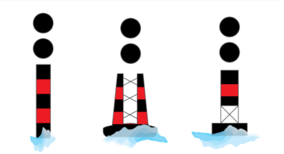
| Feature | Description |
| Color | Black and Red Stripes |
| Shape | Buoy, Pillar, or Spar |
| Top-mark | Two Black Spheres |
| Light | White |
| Rhythm | Group Flashing(2) FL(2) |
| Chart Symbol | 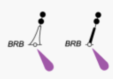 |
8.1:- Navigation when an Isolated Danger Mark is Sighted:
The principal idea of Navigating an Isolated Danger Mark is to pass at a safe distance on any side of the mark. The Safe distance is calculated after consulting the Chart.
9:- Safe Water Mark
There is navigable water around a safe water mark in the IALA Buoyage System. It usually marks the middle of a channel or passage going towards a harbor. They also guide a vessel to a safe zone or area, especially where there are rushing and complicated waterways.
| Feature | Description |
| Color | Red and White Vertical Stripes |
| Shape | Buoy, Pillar, or Spar |
| Top-mark | Single Red Sphere |
| Light | White |
| Rhythm | OccultingIsophaseLong Flash every 10 secsMorse Code Alpha(A) |
| Chart Symbol |
10:- Special Mark Buoy
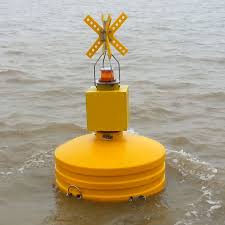
A special mark in the IALA Buoyage System is used to indicate special information or an allocated area, such as a fishing zone, anchorage, or controlled area. Special Marks are basically information-providing marks and do not indicate dangerous and safe navigation areas. They assist mariners in locating these specific areas and carry out respective local regulations.
| Feature | Description |
| Color | Yellow |
| Shape | Conical, Spar, Cylindrical, Pillar, Spherical |
| Top-mark | Yellow Cross on it’s side |
| Light | Yellow |
| Rhythm | Any rhythm except those used by other buoys |
| Chart Symbol | 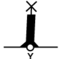 |
11:- FAQs:
- What does IALA Stand For?
IALA stands for the International Association of Marine Aids to Navigation and Lighthouse Authorities.
- What are Region A and Region B of the IALA Buoyage System?
Region A: Covers Europe, Africa, Australia, New Zealand, and most of Asia. Port side is red, starboard side is green.
Region B: Covers the Americas, Japan, South Korea, and the Philippines. Port side is green, starboard side is red.
- What is a Navigational Buoy?
A navigational buoy is a floating marker used to guide vessels, indicating channels, hazards, and safe water.
- When was the IALA Buoyage System Established?
The IALA Buoyage System was established in 1957.
Disclaimer :- The opinions expressed in this article belong solely to the author and may not necessarily reflect those of Merchant Navy Decoded. We cannot guarantee the accuracy of the information provided and disclaim any responsibility for it. Data and visuals used are sourced from publicly available information and may not be authenticated by any regulatory body. Reviews and comments appearing on our blogs represent the opinions of individuals and do not necessarily reflect the views of Merchant Navy Decoded. We are not responsible for any loss or damage resulting from reliance on these reviews or comments.
Reproduction, copying, sharing, or use of the article or images in any form is strictly prohibited without prior permission from both the author and Merchant Navy Decoded.